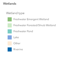
The Southeast Michigan Wetland Mapper highlights the region's diverse wetlands and their various functions. This data, sourced from SEMCOG’s Open Data Portal, is based on the US Fish & Wildlife Service's National Wetlands Inventory , updated in 2015 through collaboration with the Michigan Department of Environment, Great Lakes, and Energy (EGLE) and Ducks Unlimited, Inc. (DU).
While this dataset provides comprehensive coverage, certain wetlands are excluded due to limitations of aerial imagery, the primary data source for detection. A dataset may be empty due to a lack of available data to determine its level of contribution.
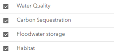
While wetlands of all sizes and types contribute to healthy ecosystems, this analysis focuses on high functioning wetlands. Specifically, this mapper highlights wetlands that function for water quality, carbon sequestration, flood storage, and habitat. View the Wetlands Storymap for additional information on wetlands in Southeast Michigan.
 feature to view wetlands by a specific county
boundary.
 for a community to view its various wetland types and acreage.
![]() .
.

![]() . You can also hide this feature using the arrows. You
can also hide this feature using the arrows
. You can also hide this feature using the arrows. You
can also hide this feature using the arrows ![]() .
.

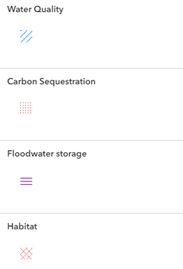
To view the wetland functions legend, click the legend button ![]() .
This legend updates dynamically based on the selected functions in the layer list.
.
This legend updates dynamically based on the selected functions in the layer list.

You can access various wetland datasets using the SEMCOG Open Data Portal links below. Available data includes wetland codes and regional and county wetland GIS datasets.
The wetland codes displayed in the mapper are from the Cowardin Classification System, a standardized method used to identify and categorize wetlands. This system defines wetlands biologically, focusing on habitat characteristics like vegetation types and the duration of water presence. These codes will be displayed in the pop-up when you click on a wetland.
The National Wetland Inventory and SEMCOG worked to simplify wetland codes by focusing on the first two characters (system and class) which provide key insights into landscape and hydrology. For a more detailed view, refer to the wetland codes dataset.
For more information contact Bailee Pasienza , Planner, Environment and Infrastructure, SEMCOG.