Close X

Southeast Michigan Eco Planning Tool

Welcome to SEMCOG’s Eco Planning Tool. This tool is designed to provide early environmental planning indicators for potential development, transportation, and green infrastructure implementation projects. Its design is based on land use and land cover changes and is compared to online databases for environmental features. These features include:

The tool will calculate environmental impacts, flag potential environmental compliance priorities, and estimate economic valuation . For road and development projects, the tool provides alternative best management practices, with cost benefits, to offset environmental impacts.

How to use:
  1. To draw your project area, click the draw polygon button, circled in red below. When your polygon is complete, double click to stop drawing.
    Draw tool
    You can adjust the estimated percent impervious change, using the sliding scale bar.
    impervious percentage tool
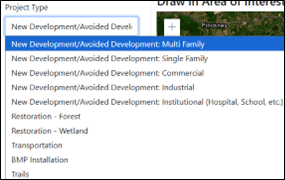
  2. Use the dropdown menu to confirm your Project Type. See below for more information on each type.
    project type dropdown
  3. Once your polygon has been drawn and your percent impervious cover and project type is chosen, click Run in the top left hand corner of the tool. This process will take a few minutes.
    run button
  4. When the "Run" is complete, you will see a text summary of the tools run appear on the right hand side. Click the tabs at the top of the map to navigate through the tool and understand the impact of the project, the compliance issues the project may trigger and understand potential mitigation opportunities and economic considerations of those mitigation opportunities
    • Impact tab provides detailed environmental impacts.
    • Compliance tab provides information on potential regulatory and compliance considerations.
    • Mitigation tab provides information on the environmental and economic benefits of stormwater Best Management Practices (BMPs)
    • Economic Considerations tab provides information on the costs of BMPs.
Project Types

For more information contact Bailee Pasienza, Planner, SEMCOG Environment & Infrastructure

About
Please input an AOI before running

Project Footprint

Draw in Area of Interest

Please input an AOI before running

Running… Please wait for results.

Disclaimer

This is an environmental indicator tool that aims to:
• Guide decision-making in the planning process.
• Provide ballpark estimates of the types and potential magnitudes of environmental impact and costs and benefits of different development options; site-specific investigation is required for more accurate estimates.
• Highlight possible regulatory compliance concerns (with the exception of archeological/historical resources, which are not addressed in the tool).

The tool does not substitute for a thorough environmental review.

Existing Land Use

Existing Land Cover Areas (Acres)

Tree Cover

Impacts

Land Cover Impacts (Acres)
Impervious Surface Change
Annual Air Quality Impacts (lbs./year)
Increase in NO2 (Nitrogen dioxide)
Increase in SO2 (Sulpher dioxide)
Increase in O3 (Ozone)
Increase in CO (Carbon Monoxide)
Increase in PM10 (Small Particulate Matter)
Increase in CO2 (Carbon dioxide)
Annual Water Quality Impacts (lbs./year loading into nearby waterbodies)
Increase in Nitrogen
Increase in Phosphorus
Increase in Sediment
Annual Stormwater Runoff Impacts (gallons per year)
Increase in Runoff

Trees provide aesthetic benefits which will be affected by the removal of tree cover.

Potential Regulatory Compliance Considerations

Wildlife Collisions

[TRANSPORTATION PROJECTS ONLY] The proposed project is located in an area where wildlife vehicle collisions have previously happened. Project considerations for wildlife crossings can include bridges, tunnels and culverts that allow wildlife to safely pass from one side of the road to the other. To learn more about Wildlife Crossings, visit the U.S. Department of Transportation Federal Highway Administration

Wetland Restoration Opportunity

The proposed project has a high potential for wetland restoration. There may be wetland restoration opportunities to help mitigate localized flooding and support resiliency initiatives. Please consider communicating with SEMCOG if interested in exploring these opportunities.

Wetland Permit

The proposed project is located in proximity to a wetland that may be regulated by the State of Michigan. A permit from the Michigan Department of Environment, Great Lakes, and Energy (EGLE) is required for certain activities in regulated wetlands. Regulated wetlands include those more than 5-acres in size or contiguous to a water body. To learn more about wetland regulations, visit the Department of Environment, Great Lakes, and Energy’s website.

MS4 Permit

If the proposed project is 1-acre or greater in size, then county or local post-construction stormwater standards may apply. This is part of the local or county Phase II Municipal Separate Storm Sewer System (MS4) permit. This includes implementing Best Management Practices that control runoff volume to the Maximum Extent Practicable. Utilizing this tool, you can determine what best management practice may be beneficial to include as part of your project, to protect water quality.

Parks Opportunity

The proposed project is located in an area without adequate access to outdoor recreation space, and nearby residents do not have a park within 10-minute walking distance. If possible, your project could consider opportunities to connect people with recreation opportunities in the area.

Impaired Watershed

The proposed project is located near an impaired water body, meaning water quality is compromised. Visit the Department of Environment, Great Lakes, and Energy’s website to learn more about how your project can protect water quality.

Flood Exposure

The proposed project is located in an area where transportation assets are at high risk of flooding. Transportation project sponsors are regularly recommended to consider addressing assets at high risk for flooding and to include appropriate stormwater best management practices.

Community Outreach

Conducting engagement and outreach with local community members helps project planners better understand community priorities and ensures that the project meets the needs of diverse community stakeholders. This project may impact surrounding community members. The project sponsor should consider communication and outreach to local community members and stakeholders as part of the project.

Threatened and Endangered Species

The proposed project is located within an area that has a high bio-rarity score, indicating a high likelihood of having one or more threatened and endangered species within this area. In accordance with the United States Environmental Protection Agency, there may be additional requirements to evaluate the impact it will have on that species or ecosystem, and you may need to work through the National Environmental Policy Act (NEPA) process to formally determine the environmental impacts. Learn more about NEPA and what may be required through the Michigan Department of Transportation.

Annual Best Management Practice (BMP) Benefits

per Installed 1000 CF BMP Capacity or per Planted Tree

Estimated environmental benefit of each key type of BMP (offsetting/reducing the environmental impact presented in the 'impact' tab). Negative values indicate reduced pollution.

Benefit per Year Tree Bioretention
(Small green infrastructure)
Infiltration Trench Porous Pavement Extended Detention
Air (lbs./year)
NO2 0 Not Quantified 0 Not Quantified Not Quantified
SO2 0 Not Quantified 0 Not Quantified Not Quantified
O3 0 Not Quantified 0 Not Quantified Not Quantified
CO 0 Not Quantified 0 Not Quantified Not Quantified
PM10 0 Not Quantified 0 Not Quantified Not Quantified
CO2 0 Not Quantified 0 Not Quantified Not Quantified
Water (lbs./year loading into nearby waterbodies)
Nitrogen 0 0 0 0 0
Phosphorus 0 0 0 0 0
Sediment 0 0 0 0 0
Annual Stormwater Runoff Impacts (gallons/year)
Runoff 0 0 0 0 0

This tab provides information on the economic costs and the value of environmental benefits (as quantified in the mitigation tab) of installing green stormwater infrastructure.

Costs per 1000 Cubic Foot (CF) Capacity of BMP or Per Tree

Installation and operations, maintenance, and repair (OMR) costs for stormwater management best management practices (BMPs).

BMP Capital Cost Annual OMR Costs Expected Life Annualized Cost
Bioretention $19,260 - $59,860 $1,801 - $8,978 20 years $3,530 - $13,270
Infiltration Trench $15.56 - $15.85 $0.56 20 years $1.25 - $1.83
Porous Pavement $6,696 - $101,598 $27,710 20 years $28,240 - $35,860
Extended Detention $2,880 - $208,880 $100 - $2,580 20 years $330 - $18,100
Tree (per tree) $10 - $510 $0 - $20 80 years $5,280 - $39,940

Economic Value of Benefits per 1000 CF Capacity or Per Tree

Economic value of the improvements in air and water quality provided by BMPs (as quantified in the mitigation tab).

Benefit per Year Tree Bioretention Infiltration Trench Porous Pavement Extended Detention
Air
NO2 $0.01 0 0 0 0
SO2 $0.001 0 0 0 0
O3 $0.10 0 0 0 0
CO $0.11 0 0 0 0
PM10 $0.56 0 0 0 0
CO2 $3.34 0 0 0 0
Water
Nitrogen 0 0 0 0 0
Phosphorus 0 0 0 0 0
Sediment 0 0 0 0 0
Runoff 0 0 0 0 0

Other Benefits

Per Tree
Aesthetic Benefit $400
Energy Savings $22
Pavement Maintenance $4-$19